
Soil is the fundamental building block for arable farming, and keeping that soil in prime condition is the ultimate goal of farmers who are looking to maximise yields and therefore profits.
That ambition can often mean adding fertiliser, lime or organic matter to the soil in order to keep it in top condition or replenish nutrients, but with the cost of inputs coming off the bottom line, it’s equally important to add only what is necessary to achieve the soil’s maximum potential.
The only cost-effective way of achieving the best soil at the lowest price is to assess its current make up accurately enough to allow the farmer to add exactly what is needed.
That ambition needs careful and comprehensive soil sampling and mapping, which is where Farm Image, based just outside Faversham in Kent, can play such a vital part in boosting soil health and productivity.
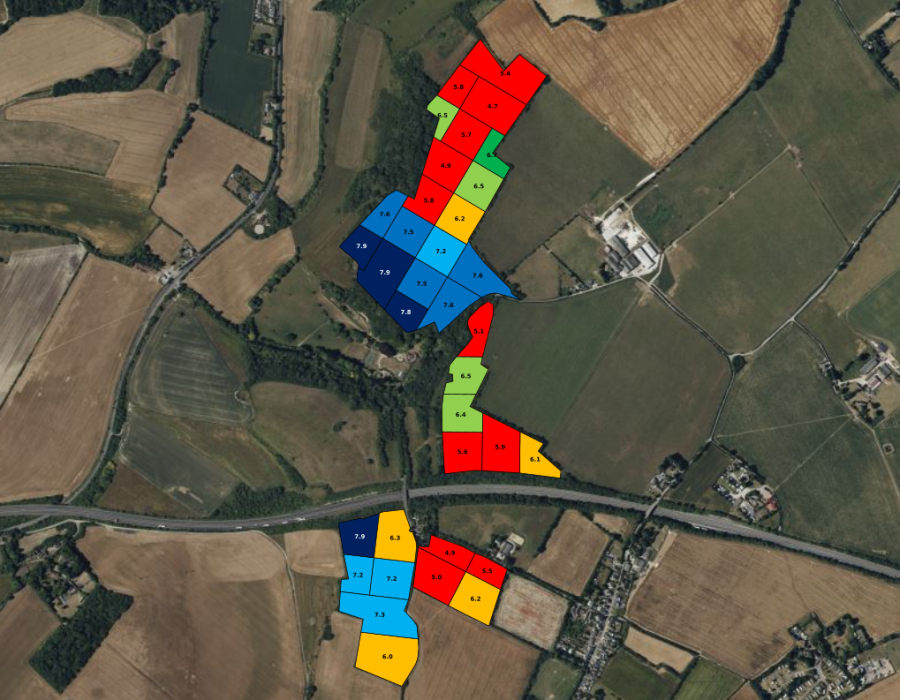
pH map viewed on Farm Image’s SoilSmart system
With 25 years’ experience in soil nutritional management services, the company offers a range of mapping and sampling services and uses the latest technology to help farmers understand what’s below the surface of their fields and how they can improve it cost effectively.
That technology includes a state-of-the-art Veris U3 scanner that can identify the amount of organic matter at a range of points across a field and can also be used to map water capacity and nitrogen risk and inform variable rate planting, particularly for high value crops.
Standard soil sampling for pH, phosphate, potassium and magnesium is carried out by Farm Image using the standard RB209 method to give accurate averages for each field, while colour coded results highlight what action needs to be taken. Farm Image can also provide a nutrient management plan for the following four years.
“The Environment Agency has upped the number of inspectors and is increasingly keen to make sure farmers comply with the rules,” explained Farm Image director Louise Burley. “In addition, most Sustainable Farming Incentive actions and accreditation schemes require the farmer to know the make-up of his or her field, besides which it plays a big part in how productive it is.”
While hand augurs are still used on occasions, most of the work is now done using Can-Am all-terrain vehicles mounted with Wintex automatic samplers. While the standard depth for a sample is 15cm, Farm Image has also invested in a Wintex 3000, which can reach 90cms into the soil and can take three samples, one at 0cm to 30cm, one at 30cm to 60cm and one at 60cm to 90cm and is used for soil mineral nitrogen and carbon sampling.
Farm Image has built up an impressive reputation and its four-strong soil sampling team is kept busy year-round sampling fields from as far afield as York, Birmingham, Cornwall, Cumbria and the Isle of Wight, as well as the whole of the South East.
Georgia Straker, who looks after environmental compliance for the Farm Image team, pointed out that it wasn’t just larger farms that needed to be aware of their responsibilities.
“We had a call last year from someone with a 12-acre holding on which she kept a small flock of sheep,” she explained. “She had had a visit from the Environment Agency, which then sent her a long list of requirements which she was struggling to understand and deal with.
“We were able to advise her on their requirements and we also analysed her soil and pointed out where the organic matter from her flock would improve the soil, whereas she had just been spreading it anywhere. It’s not just a matter of complying with the rules, but of making the best use of what you have. She was delighted that we were able to help.”
Being able to create detailed maps of where nutrients are lacking allows farmers to use variable mapping when applying the necessary fertilisers and avoid using more than they need.
Another popular service offered by Farm Image is providing a pH analysis and mapping service, usually at one-hectare intervals, and creating a variable rate spreading map for lime. “Oilseed rape and barley, in particular, benefit from the right pH level, and the relatively low cost of precision mapping avoids spreading lime where it isn’t needed,” said Louise. Farm Image offers a full liming service, including supplying and variable rate spreading.
Farm Image’s free online SoilSmart system also allows the farmers themselves to access all the data, which is stored in ‘the cloud’ and is available not just to the company’s expert analysts but to the individual farmer, who can use the data however they wish. The data itself is supplied by an independent laboratory to which Farm Image sends the samples it collects.
In another nod to rapidly advancing technology, Farm Image also offers satellite imagery using either the Sentinel 2 or Planetscope systems. Optical sensors mounted on satellites measure the variation in the crop canopy during the growing season and can allow Farm Image to prescribe variable rate nitrogen and plant growth regulator applications aimed at boosting low performing areas.
“Again, the farmer can use SoilSmart to identify areas that need more nitrogen and create their variable rate application programme themselves, or they can ask one of our team to set it up for them,” said Louise.
Other important members of the customer-focused Farm Image team are sales director Steve Hammond, Hannah Gorman, who looks after agricultural sales alongside Steve, and Bel De’ath, who handles compliance admin.
Georgia, Hannah and Louise
For more like this, sign up for the FREE South East Farmer e-newsletter here and receive all the latest farming news, reviews and insight straight to your inbox.